We now have a map of our entire ODYSSEY route thanks to Denise Roberts from my work. If you click on the words "ODYSSEY MAP" below, the address should come up. Then just click on the link and you will see a wonderful map. The map lists places we visited and some of our activities.
THANKS so much Denise!
ODYSSEY MAP
Monday, August 16, 2010
Wednesday, August 11, 2010
August 8, 2010 - We're Home!
August 4, 2010 We left Butte and headed for Couer d'Alene, Idaho. The drive was interesting in that we experienced a couple of different types of topography. We drove through more prairie, then through a section of mesa, much like parts of Arizona that we have experienced, and we also had some mountain (hills really) terrain. Once we got to Missoula, we were tracing, in reverse direction, our Summer trip of last year when we drove out to Missoula and into Glacier National Park.
It was a long day on the road and we pulled into Couer d'Alene RV Resort in Post Falls, Idaho. Post Falls is just west of Couer d'Alene. We spent 3 nights there just relaxing and reflecting on our trip and I went golfing one day. We didn't do the touring bit because last year we spent time in Couer d'Alene and Spokane, so we choose to relax.
August 7, 2010 We continued our journey westward across the width of Washington, stopping at the Tulalip
Casino in Marysville, Washington. This casino is a stop over for many RVers and they even have a parking lot designated for RVs.
Casino in Marysville, Washington. This casino is a stop over for many RVers and they even have a parking lot designated for RVs.
 Driving across Washington we passed over Lake Wanapum which is the dam lake on the Columbia River.
 The view of the Lake is very impressive and in the distance you can see the bridge were Hwy. 90 passes over it.
 As we approached the Cascade Mountains it began to drizzle and rain off and on. I was concerned about driving over the Snoqualmie Pass because from the West it is quite a climb. What I didn't realize is driving East to West you approach the Pass and you are already at about 2500 ft. so the Pass it not that big a deal.
On our entire journey we only saw 3 major accidents, and 2 of them were on our second to last day as we drove through Seattle. One of them happened just ahead of us, as three cars piled into each other and on the slick road, it was all I could do to get my skidding truck and RV stopped in time. It was interesting that as we approched home, the rain began.
We arrived home in the morning of August 8 and were welcomed by the grandkids and family. It was odd to be home, as being travellers for 4 months had begun to feel like our normal lifestyle. However, both of us agree that we could not RV full time, as many people do. This trip was really an odyssey for us as every day brought new experiences and places. Now we have experience certain areas, we know where we would like to some day return, and that may be some of our future trips. The truck and RV performed wonderfully and the trip served to strengthen the relationship between Laurie and I. It truly was the trip of a life time; an ODYSSEY to be sure.
2010 Odyssey Summary:
* 4 months
* 16 weeks + 2 days
* 114 days
* 22,105 kilometers
* 13,735 miles
* 33 states
* 5 provinces
* Fuel: $3,750 (24% of expenses)
* RV Sites $3700 (23% of expenses)
* Groceries $2,500 (15% of expenses)
Now, what will our next dream be!!!
Tuesday, August 3, 2010
Slight Change in Plans
My last Blog indicated that we would be heading toward Great Falls, Montana, and then north to Calgary and return through BC. Well, we had a slight change in plans. After an in-depth executive meeting, our truck and RV were given orders to "stay the course", meaning, continue on Hwy 94 through Montana (Hwy 94 becomes Hwy 90), cut across the neck of Idaho, travel through Washington to the Pacific Ocean at Seattle, and then turn north and head home. Once we get to Missoula, we will be retracing our trip of last Summer into Montana, only going in the opposite direction. Our decision was based on the fact that we love Montana, things are so much cheaper in the United States, and we are following an awesome highway.
 Upon leaving Minneapolis, Minnesota we wanted to get across the "prairies" as quickly as possible. Therefor we put in 3 solid days of driving
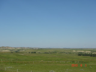
This picture is typical of the Western part of Minnesota, most of North Dakota, and Montana, along Hwy 94.
July 31: Minneapolis to Jamestown, North Dakota 530 kms
Aug 1 : Jamestown, ND to Forsyth, Montana 666 kms
Aug. 2: Forsyth, MT to Butte, MT 525 kms
 After we passed Billings, MT we were quite excited to finally see mountains on the horizon. It has been months since we have seen, what us Westerners call "mountains". The only unfortunate part about being in the mountains is that we had to cross a mountain pass and our truck really had to work hard to get us to the summit. That is the first of numerous summits that we will have in our way to the Pacific Ocean.
 We were glad to make it to Butte, Montana (pronounce it as you will??) were we stayed in a KOA for a couple of nights. In the late 1800s Butte was a major copper mining town and they called it the "Richest Hill on Earth". Many a fortune was made in this town and miners flocked there to seek work. The Historic Butte is built on a side of a hill, because that is were the mines were and were the workers wanted to live.
This picture is taken from the top of the hill with a view of old Butte and a mine tower (black) in the foreground. The towers were used to lift men and materials down into the mines.
 Much of the Historic town has been well preserved and it is a beehive of tourist and commercial activity. There are numerous mansions and historic sites for tourist to visit. Laurie and I went for lunch in the old "Metal Bank of Butte" which has been rejuvenated as a Sports Bar and Restaurant. This vault door and frame took a team of 28 horses hours to haul up the hill to the bank when it was under construction. It did strike me as odd to have the old town built on the side of the hill instead of down in the valley were you will find most towns.
Observation: * Since we arrived on the Gulf Coast months ago we watch the local news cast, usually at 6pm. On almost all occassions, the weather portion of the news is named to reflect extreme weather conditions; Storm Watch, Weather Alert, Severe Storm Tracker, etc. That is because in the late afternoon it is common for a weather system to create severe thunderstorm conditions including flash flooding. In Vancouver, we have such calm weather conditions in comparison.

This picture is typical of the Western part of Minnesota, most of North Dakota, and Montana, along Hwy 94.
July 31: Minneapolis to Jamestown, North Dakota 530 kms
Aug 1 : Jamestown, ND to Forsyth, Montana 666 kms
Aug. 2: Forsyth, MT to Butte, MT 525 kms
 After we passed Billings, MT we were quite excited to finally see mountains on the horizon. It has been months since we have seen, what us Westerners call "mountains". The only unfortunate part about being in the mountains is that we had to cross a mountain pass and our truck really had to work hard to get us to the summit. That is the first of numerous summits that we will have in our way to the Pacific Ocean.
This picture is taken from the top of the hill with a view of old Butte and a mine tower (black) in the foreground. The towers were used to lift men and materials down into the mines.
 Much of the Historic town has been well preserved and it is a beehive of tourist and commercial activity. There are numerous mansions and historic sites for tourist to visit. Laurie and I went for lunch in the old "Metal Bank of Butte" which has been rejuvenated as a Sports Bar and Restaurant. This vault door and frame took a team of 28 horses hours to haul up the hill to the bank when it was under construction. It did strike me as odd to have the old town built on the side of the hill instead of down in the valley were you will find most towns.
Subscribe to:
Posts (Atom)